GeoJSON Map Viewer

Simon Willison's Blog Tools

Summary

A web-based tool for viewing and customizing GeoJSON data on an interactive OpenStreetMap, developed with AI assistance and useful for visualizing geographic boundaries.

No content available
Original Article
View Cached Full Text

Cached at: 09/02/26, 03:47 AM

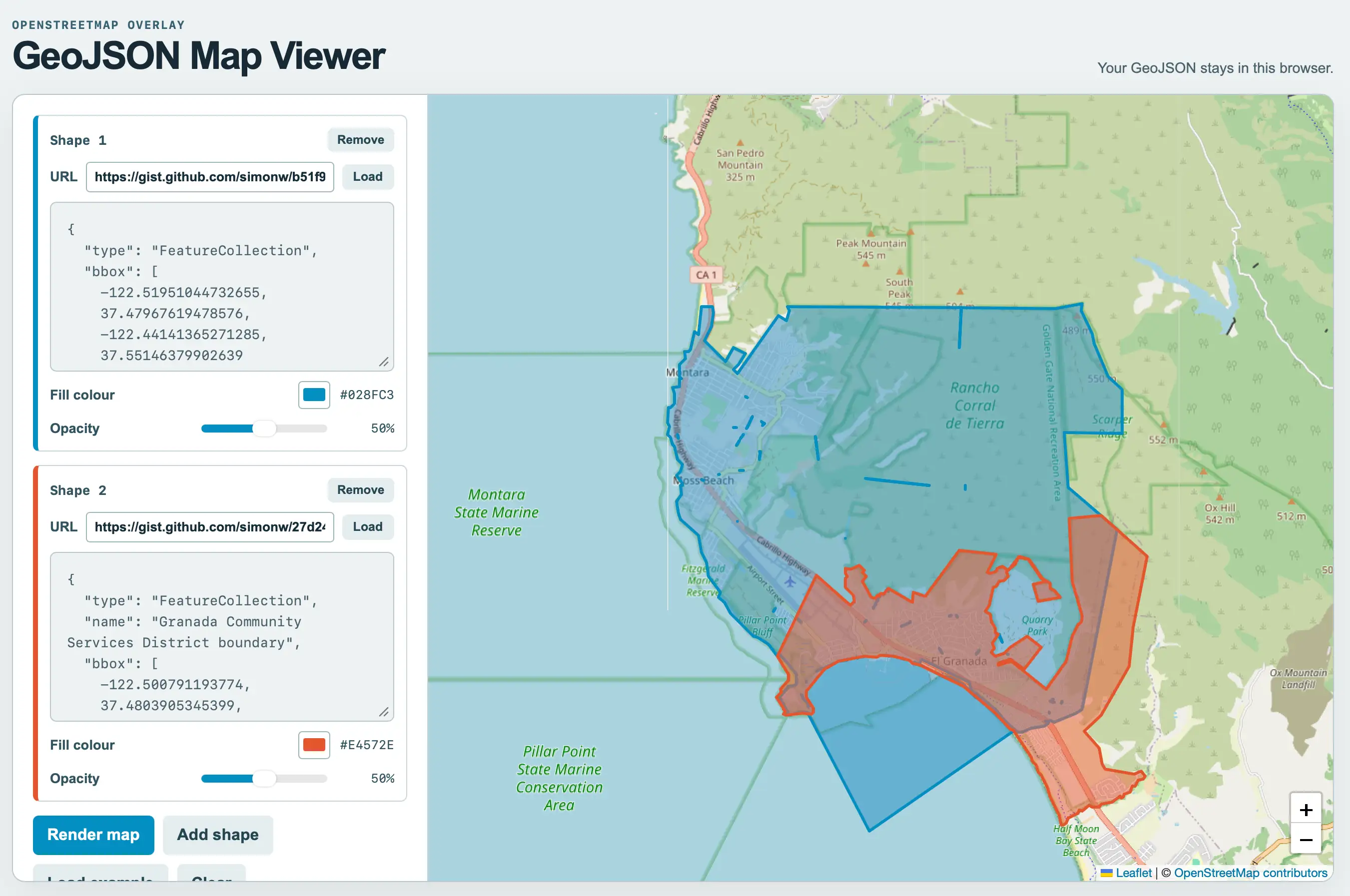
# Tool: GeoJSON Map Viewer Source: [https://simonwillison.net/2026/Sep/1/geojson/](https://simonwillison.net/2026/Sep/1/geojson/) [Tool](https://simonwillison.net/elsewhere/tool/)[GeoJSON Map Viewer](https://tools.simonwillison.net/geojson)— View and visualize GeoJSON data on an interactive OpenStreetMap with customizable styling options\. Paste GeoJSON objects \(Feature, FeatureCollection, or Geometry\) into the editor, adjust fill color and opacity, and render the features directly on the map\. I was helping Natalie gather some maps of local political boundaries \(for the[Granada Community Services District](https://granada.ca.gov/)and the[Midcoast Community Council](https://midcoastcommunitycouncil.org/)and found a need to display some GeoJSON files on a map and export that as a PNG\. I asked GPT\-5\.6\-Sol for suggestions of tools and it proactively built one\. After[some iterations](https://tools.simonwillison.net/colophon#geojson.html)using Claude Code for web and Fable 5\.1 we got to this finished tool\. As for the GeoJSON\.\. it turns out if you ask ChatGPT Work to provide boundaries for almost anything it will churn away extracting and combining files from different Government data sources and build exactly what you need\. I got[this polygon](https://gist.github.com/simonw/27d243c9d1cb5d9047fff7360dd49d3c)from: > `I want a polygon that represents the exact boundary of the El Granada GCSD` And[this one](https://gist.github.com/simonw/b51f9e0190a13932ac64a0cb407a709d)from: > `Get me a GeoJSON file for the boundary \(or boundaries if that makes sense\) for the MCC \- Midcoast Community Council \- that operates near Half Moon Bay CA` [Here's a link](https://tools.simonwillison.net/geojson#url=https%3A%2F%2Fgist.github.com%2Fsimonw%2Fb51f9e0190a13932ac64a0cb407a709d&color=%23028FC3&opacity=50&url=https%3A%2F%2Fgist.github.com%2Fsimonw%2F27d243c9d1cb5d9047fff7360dd49d3c&color=%23E4572E&opacity=50&preset=map&resolution=2&lat=37.52640&lng=-122.48297&zoom=13)that displays both of them at the same time on the new GeoJSON map viewing tool\. ![Screenshot of a web app with a left sidebar of controls and a large map on the right. Top left: OPENSTREETMAP OVERLAY GeoJSON Map Viewer. Top right: Your GeoJSON stays in this browser. Sidebar Shape 1 panel with blue accent: Shape 1, Remove button, URL https://gist.github.com/simonw/b51f9 with Load button, textarea containing { "type": "FeatureCollection", "bbox": -122.51951044732655, 37.47967619478576, -122.44141365271285, 37.55146379902639, Fill colour #028FC3 with blue swatch, Opacity slider at 50%. Shape 2 panel with red accent: Shape 2, Remove button, URL https://gist.github.com/simonw/27d24 with Load button, textarea containing { "type": "FeatureCollection", "name": "Granada Community Services District boundary", "bbox": -122.500791193774, 37.4803905345399, Fill colour #E4572E with red swatch, Opacity slider at 50%. Buttons: Render map, Add shape, Load example, Clear. The map shows the coast around Montara, Moss Beach, El Granada and Half Moon Bay with a large semi-transparent blue polygon covering Montara, Moss Beach and Rancho Corral de Tierra extending into the ocean, and an overlapping red polygon covering El Granada and Quarry Park. Map labels include Cabrillo Highway, San Pedro Mountain 325 m, Peak Mountain 545 m, South Peak, CA 1, Montara, Rancho Corral de Tierra, Golden Gate National Recreation Area, 489 m, Scarper Ridge, 552 m, Moss Beach, Montara State Marine Reserve, Ox Hill 542 m, 512 m, Fitzgerald Marine Reserve, Airport Street, Pillar Point Bluff, Quarry Park, El Granada, Pillar Point State Marine Conservation Area, Ox Mountain Landfill, Half Moon Bay State Beach, plus and minus zoom buttons, and attribution Leaflet | © OpenStreetMap contributors.](https://static.simonwillison.net/static/2026/geojson-tool.webp)
Similar Articles

GeoJSON

Hacker News Top

GeoJSON is an open standard format for encoding geographic data structures using JSON, supporting various geometry types and standardized as RFC 7946 by IETF in 2016.

opengeos/GeoLibre

GitHub Trending (daily)

GeoLibre is a free, open-source, cloud-native GIS platform for visualizing, exploring, and analyzing geospatial data, running in browsers, desktop, mobile, and Jupyter notebooks.

GeoLibre 1.0

Hacker News Top

GeoLibre 1.0 is a lightweight, cloud-native GIS platform for visualizing, exploring, and analyzing geospatial data, built with modern web technologies and running across desktop and web environments.